Tuesday, August 31, 2010

Heading Home


They have plenty of snow fences

Aug 30th and 31st
Left Welches Oregon on Mon morning and drove out of the Mt Hood area and onto I-84 heading East. We traveled 465 miles thru Oregon and Idaho and arrived at Mountain Home Idaho where we spent the night. We left Tues morning and drove thru Idaho, Utah and Wyoming on I-84 and then picked up I-80 and drove 434 miles to Rock Springs Wyoming where we will spend the night. Weather has been great. A few sprinkles with the temp around 70. The scenery thru the Rockies has been great.

Sept 1st (Wed)
Another beautiful day. Traveled thru Wyoming and Nebraska for a total of 481 miles, all on I-84. The wind was awful but the scenery was great. With these winds, it is no wonder that they need snow fences.

Sept 2nd (Thurs)
Another good day. We traveled 447 miles on I-80 thru Nebraska and Iowa. The wind was strong out of the North so it was a day's work. We are in Newton Iowa where we will spend the night.


Sept 3rd and 4th (Sat)
We are home.  We traveled in Iowa on I-80 to Davenport where we turned south on I-74 and headed for Indianapolis Indiana.  The wind was strong from the west so we got some bad gusts when we were going south.  It was nice when we were going east.  In fact, I got almost 11 mpg going east.  We traveled 425 miles on Friday and spent the night in Indianapolis.  We then got on I-70 and completed the last 147 miles on Saturday.  It was nice to head down Route 49 and then Route 35 into Beavercreek.  The miles for the total trip were 5,459 miles.

Saturday, August 28, 2010

Welches at the base of Mt. Hood

This is the Resort where we are camping

Yes there is a Boring Oregon

Super Launcher at the watermellon launching contest

Man vs Woman in watermellon launching contest

One of the teams in the watermellon launching contest

Mt Hood taken from Timberline Lodge


Aug 28th (Sat)
We drove 64 miles today on very curvy roads and ended up in Welches which is in the foothills of Mount Hood. The top is covered with snow and the trees are so thick that you can not walk between them. We had dinner tonight at the Timberline Lodge which is 20 miles from Mt Hood Village Park where we are staying. The elevation is 6000 feet and when we came out from dinner, the temp was 40 degrees. During the day at the park, they had a watermelon launch contest. Sure was crazy.

Aug 29th (Sun)

Today was sort of a day of rest. It did not get out of the 60s today. We drove out Route 26 to a little town called Boring Oregon. That was about it. Tomorrow, we hit the road to travel almost 2500 miles to get back to Ohio.

Thursday, August 26, 2010

Memaloose State Park

Beech at Horsetail Falls in Oregon on Columbia River

This is Multnomah Falls on the Columbia River

Picture taken from the Crown Point Vista House

Crown Point Vista House

The Crown Point Vista House is on the very top of this mountain

The owl that we saw at the Discovery Center

Aug 26th (Thur)
Trip meter reads 2996 so we traveled 149 miles today in a bad wind. It was a steady wind of over 25 miles per hour and gusts up to 50 mph. Sure does keep you on the ball while you are driving. We stopped at Columbia Gorge Discovery Center which explained the history from the Ice Age to the present. Also listened to a young lady tell us all about the owl. She can not move her eyes but can turn her head almost 360 degrees. We then drove on into Memaloose State Park where we will spend two days.

Aug 27 (Fri)
After the wind yesterday, the high was about 70 today. We traveled along Oregon 30 and looked at all the Falls. This is the Historic Columbia River Highway. We then went up Larch Mountain which is 4055 feet elevation. The temp dropped over 20 degrees as we went up the mountain. From the top, you can see Mt Helens, Mt Rainer, Mt Adams, Mt Hood and Mt Jefferson. We then stopped at the Chicken and Dumplings in Troutdale and ate Chicken and Dumplings.

Tuesday, August 24, 2010

Pendleton Oregon


This is the road that we come down Blue Mountain.  6% Incline

Working girls room in the brothel

Underground Chinese bunkhouse and jail

Chinese opium room where they lay down to smoke


Aug 24th (Tues)
We drove 90 miles today and we are in Pendleton Oregon on the Umatilla Indian Reservation at Wild Horse Casino.  We traveled down the Blue Mountains which were kind of steep.  When we arrived, we went thru the Tamastslikt Culture Center which is all about the Indians.  It was a lot of reading so I would rate it as fair.  We tried out the Casino and Ellen won $20.  The weather is nice and in the 80s with plenty of sun.

Aug 25th (Wed)
We are still in Pendleton and the temp is back up to 98 degrees.  This morning, we went to Pendleton Historic Underground.  It is all underground and was a place to drink and gamble.  There was also a brothel in the hotel over the Underground places.  There were 37 brothels in Pendleton which did not shut down until some time in the 60s.  It was also a place for the Chinese that worked on the railroad.  They lived there and even had their own jail.  We then went to the Pendleton Wool Outlet and watched them making Indians blankets.  They are very expensive.

Saturday, August 21, 2010

Baker City Oregon

This is the wood driven, narrow track steam engine

Dredge used to dig for gold


We visited this Interpretive Center today.  Very nice

This is the one mile road to the Interpretive Center

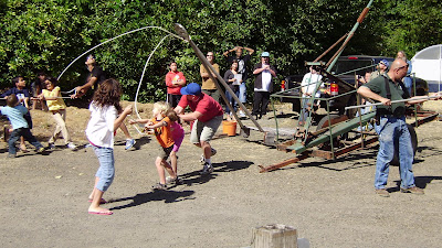
Look close and you can see how they pull these wagons today


Aug 21st (Sat)
Another warm day in the mid 90s but it has cooled off this evening and we have the windows open.  Trip meter reads 2757 so we drove 201 miles today and we are in Baker City Oregon at the Mountain View Holiday Trav-L-Park.  We took a long walk thru the Interpretive Center.   Very nice.

Aug 22nd (Sun)
The temp did not get above 70 degrees today.  Best day we have had in a month.  We went for a train ride on a wood driven, narrow track, steam engine.  The track is 36 instead of 48 ½ inches.  It was an open air ride and we saw a couple of deer.  You could ride inside but most stayed outside.  We also saw one of the dredges that they used to dig for gold.  Ellen and Carol fixed a nice pork loin dinner for everyone tonight.  Then we played a couple games of 31.

Aug 23rd (Mon)
Today was a day of rest. We drove around town but that was about it. The high temp was around 70 degrees again today.

Friday, August 20, 2010

Glenn's Ferry, Idaho

These Wheel Chairs are all over town in Glenn's Ferry

Ellen and I have finally made it to a wheel chair

Three Island Crossing in Glenn's Ferry Idaho


Aug 20th (Fri)
We drove 56 miles today and ended up at Glenn’s Ferry Idaho at the Three Island Crossing State Park. We saw Three Island Crossing where the pioneers crossed the Snake River. They used two of the three islands to cross the river and lost several wagons and people. Still about 97 degrees. Went to a murder mystery tonight and it was very dumb but funny.

Thursday, August 19, 2010

Shoshone Falls


Shoshone Falls in Idaho

Snake River in Idaho at Shoshone Falls


Aug 19th (Thurs)
Trip reader is 2500 so we traveled 88 miles today and stopped at  the Twin Falls Jerome KOA.  Back in the 90s again but we went anyway.  Visited the spot that Evel Knievel tried to jump the Snake River and all there is is a dirt ramp.  We then visited the Shoshone Falls which is in the Snake River.  This is a beautiful sight.  We then drove to Twin Falls and the falls are not near as big.  A power plant has control of most of the water.

Wednesday, August 18, 2010

Massacre Rock State Park


Snake River from Massacre Rock State Park

Geyser in Soda Springs Idaho

Aug 18th (Wed)
Trip reader at 2412, so we traveled 127 miles today. Still hot.  Reached 95 degrees today.  We stopped at Soda Springs Idaho where there is a geyser that goes off every hour on the hour.  It is carbon dioxide that mixes with water and sprays into the air.  They have it on a timer so it is controlled.  We stopped at Lava Hot Springs but the construction around the city was so bad we kept going.  We are now at Massacre Rocks State Park near American Falls Idaho.  We saw Register Rock where the emigrant camped and wrote their names on basalt boulders.  Bill, Carol and Ellen are visiting the Lander Road Ruts but they had to walk 1.6 miles so I stayed in the motorhome.


Tuesday, August 17, 2010

Bear Lake

Breakfast at the Truck Stop.  Larry & Dottie

Mormon Church in Paris

Bill, Carol and Ellen with big milkshake


Aug 17th (Tues)

Another warm day.  Around 90 degrees.  Glad we brought warm clothes.  We went to a truck stop and ate the largest pancakes that I have ever seen for breakfast.  Then we drove to Bear Lake which is south of town.  We went thru Paris Idaho and toured a Mormon Church that was build about 1890.  Then we drove around Bear Lake which was about a 100 miles.  We stopped in Garden City Utah for a raspberry milkshake which stood about two inches above the glass.  Good day.

Monday, August 16, 2010

Montpeiler, Idaho


They don't waste anything here.  This is a chair

This is the Trail Center that we visited

Sign on the street in Montpelier where the bank is that was robbed


Aug 16th (Mon)
We traveled 115 miles today thru some very barren but beautiful country.  The camping spot tonight will be Montpelier Creek KOA.  The temp was cooler but still got close to 90 after we arrived in the park.  We went to the Oregon/California Trail Center which was three floors. First floor was the journey from Independence Missouri to the Oregon Territory.  The second floor was quilts and a lot of history reading and the basement was about trains and the old way to travel.  Most folks liked it but I am getting tired of reading.  We then drove into Montpelier and saw the Montpelier Bank that Butch Cassidy robbed and never got caught.

Sunday, August 15, 2010

Fort Bridger


Home of Jim Bridger and later a hotel
ll

Officers Quarters at Fort Bridger

Sign at the entrance


Aug 15th (Sun)


Trip reading is 2170 so we traveled 172 miles today and stopped at the Lyman KOA for the night. Temp is back in the 80s but the humidity is lower so it is great. We drove about 50 miles up hill heading for the Continental Divide. The elevation at the Continental Divide is 7550 feet. The land is very barren but the formation of the rocks is beautiful. We saw deer and antelope along the road. This must be where the deer and the antelope play. This afternoon we visited the Fort Bridger Historic Site. This fort was established by Jim Bridger and Louis Vasquez in 1843 as an emigrant supply stop alone the Oregon Trail. It was obtained by the Mormons in the 1850s and then became a military outpost in 1858.


Saturday, August 14, 2010

South Pass & Atlantic City


Big city. Population 5 but the Oregon Trail went thru here and later there was a gold mine

Atlantic City between Lander and the Continental Divide

Big city of South Pass.  I think the population is 7

This is the first Masonic Lodge in Wyoming.  Located in South Pass.

This restaurant is in Atlantic City.  We are there and they had an interesting menu.  Bill got a haircut here by the Crazy Lady.

Aug 14th (Sat)
The temp got below 50 last night and only got in the 70s today.  Spent the day traveling around Lander.  We went to South Pass in Sink Canyon and saw an old town and a gold mine.  They have the first Masonic Lodge in Wyoming which was in the jurisdiction of Nebraska.  From there, we traveled to Atlantic City which is another town that the emigrants traveled thru.  We ate dinner in Atlantic City and they had bull balls on the menu.  Interesting towns but there is nothing on the land.  No trees or grass.  In Atlantic City, we saw three deer run across the street.  There are a lot of Pronghorn Antelope in these hills.

Friday, August 13, 2010

Independence Rock & Devil's Pass


The Mormons took seven houses and built the Visitor's Center

Devil's Gate

Independence Rock


Aug 13th (Fri)
Trip reading is 1998 so we traveled 158 miles today.  Did you know that Wyoming is the state that produces the most coal of all the states?  That is true.  Also we saw snow on the mountains today as we drove.  Last evening in Casper Wyoming, we ate at the Poor Boy Restaurant and they served Bull Fries.  We asked the waiter what they were and he said they were like Mountain Oysters.  During the drive today, we visited Independence Rock.  This was a favorite stop for the emigrants and they carved their names in the granite.  The story goes that if they made Independence Rock by the fourth of July, they could make it over the mountains before the winter hit.  Ellen & Dottie walked to the top but the rest of us just walked the 1.25 miles around the base.  We also stopped at Devil’s Gate which is a deep cleft cut through a rock ridge by the Sweetwater River.  We also saw Rattlesnake Pass where all emigrants must pass going west.  This Pass goes around Devil’s Gate.  After that we stopped at Mormon Handcart Historic Site and Tom Sun Ranch.  This is operated by the Mormons who used handcarts instead of wagons to carry their belongings while going west.  It was cheaper for the emigrants.  We had a good day and stopped at the Sleeping Bear RV Park in Lander Wyoming.

Thursday, August 12, 2010

Casper Wyoming

Mormon wagon being ferried across the Platte River


Interesting painting of a buffalo

Officer's Quarters at Fort Caspar

Aug 12th (Thurs)
Trip reading is 1840 so we traveled 117 miles today. Staying at Bar Nunn KOA Camp Ground which is very nice. Full hookups. Temp only got to 88 degrees today. That is great and it is going down into the 40s tonight. We are in Casper Wyoming. We visited the Interpretive Center which had a nice display but to much to read. We then went to Fort Caspar Museum which is an old fort. They had a small display and then we walked thru the fort. Very nice.